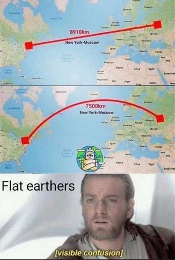
The azimuthal projection plots the surface of a globular Earth onto a flat plane. It is not a flat world model. Flight maps are not modeled on flat earth maps, they are projected onto an equidistant projection for modeling flight schedules because pilots aren't taking little globes with them.
All maps contain distortion, different maps are used for different reasons. The maritime industry uses different projections such as Cylindrical Projection like the Mercator projection. Just because this is a common model and widely used, that doesn't mean the world is a toilet roll according to sailors.
The azimuthal equidistant projection preserves both distance and direction from the central point. This is important on long-haul flights hence the choice for this projection type on modeling in the aviation industry.
Do you understand the difference in flight path distance between the 1st and 2nd picture?
Even I was a bit confused, I dont know a lot about this whole argument it seems dumb AF but is the second a shorter distance because the further up and down you get the less circumference the earth has thus making the distance shorter?
[ + ] McNasty
[ - ] McNasty 1 point 2.5 yearsDec 29, 2022 05:56:28 ago (+2/-1)
[ + ] UncleDoug
[ - ] UncleDoug [op] 0 points 2.5 yearsDec 29, 2022 06:00:27 ago (+0/-0)
[ + ] McNasty
[ - ] McNasty 1 point 2.5 yearsDec 29, 2022 06:12:47 ago (+2/-1)
https://files.catbox.moe/8lim7u.jpeg
azimuthal
https://files.catbox.moe/kocfq6.jpg
Same thing.
[ + ] UncleDoug
[ - ] UncleDoug [op] 0 points 2.5 yearsDec 29, 2022 06:32:19 ago (+0/-0)
Flight maps are not modeled on flat earth maps, they are projected onto an equidistant projection for modeling flight schedules because pilots aren't taking little globes with them.
All maps contain distortion, different maps are used for different reasons. The maritime industry uses different projections such as Cylindrical Projection like the Mercator projection. Just because this is a common model and widely used, that doesn't mean the world is a toilet roll according to sailors.
The azimuthal equidistant projection preserves both distance and direction from the central point. This is important on long-haul flights hence the choice for this projection type on modeling in the aviation industry.
Do you understand the difference in flight path distance between the 1st and 2nd picture?
[ + ] McNasty
[ - ] McNasty -4 points 2.5 yearsDec 29, 2022 06:45:56 ago (+3/-7)
[ + ] Wtf_dude
[ - ] Wtf_dude 0 points 2.5 yearsDec 29, 2022 15:41:23 ago (+0/-0)
[ + ] Deleted
[ - ] deleted 1 point 2.5 yearsDec 29, 2022 16:02:13 ago (+1/-0)
[ + ] MrDarkWater
[ - ] MrDarkWater 1 point 2.5 yearsDec 29, 2022 17:25:18 ago (+1/-0)
Geodesics look like curves on our "flattened" maps
[ + ] sguevar
[ - ] sguevar 1 point 2.5 yearsDec 29, 2022 19:54:32 ago (+1/-0)